
|
| ■Higashiyama Course (from Fushimi Inari Station to Hiei Station of Cable Car, 24.6km) |
| From Kitashirakawa to Hiei Station of Cable Car (Trail Board Number from 52-2 to 74) |
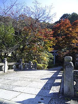  |
| Left: Kitashirakawa-tenjingu Shrine, Right: Top of Mt. Uryu-yama |
|
From Trail Board Number 52-1, cross Jyodoji-bashi Bridge along Shirakawa-dori Street and go up to the north-east. The road crosses with Yamanaka-goe (Shiga-goe) at the crossing of Trail Board Number 52-2. Turn to the right. Soon you will see Kitashirakawa-tenjingu Shrine far right. This shrine is the birthplace of Shirakawame (women from Kitashirakawa who sell flowers) and has been familiar to the Kyoto citizens since long ago. There are many poem monuments along the approach to the shrine entrance. Since ancient times, this shrine has been worshipped for the guardian deity of the Kitashirakawa area. The water of the well, which is on the right side of the Shrine gate, is known for its quality among the people who really know. Go straight on the atmospheric road to Trail Board Number 53 (junction of three roads.) The trail board is placed on the sidewalk at the junction of Shibuse-cho, in front of the gate of Jyogan-in Temple. Turn to the left to Mikage-dori Street. Turn to the right at Trail Board Number 54, which is on the north sidewalk, and head for The Japan Baptist Hospital. Kitashirakawa Shibuse-cho is the turning back point for Kyoto City Bus No.3. The toilet facility for the bus stuff is available to use through the courtesy of the local residents. Please ask permission before you use it. From Trail Board Number 55 take the right road to the hospital parking lot. The path along the stream is not good. But even you take the shrine approach road to Oyamatsumi-jinjya Shrine (Chiryu Daimyojin Shrine), you will get to the path along the stream after going through the shrine grounds. Go up the path along the stream to the tree of Metasequoia. Beside the tree Trail Board Number 57-1 is placed. Here, the path is divided into two paths. If you take the course which goes through the top of Mt. Uryu-yama, go to the path along the left stream from Trail Board Number 57-1. This path is also the Kitashirakawa Historic and Natural Trail set by Kitashirakawa Local Committee. There is the stone monument of Hakuyushi at Trail Board Number 58-2. Going up further from Trail Board Number 58-3, you will get to the quarry of good Shirakawa-ishi (granites). Stone works along the path which goes to the monument of Hakuyushi are remains of the quarry. The left path which merges with the Trail path at Trail Board Number 59-2 is the pilgrimage way from Tanukidani-hudo Temple located at the foot of Kitayama. There are many Sho-shis (small shrines) along the path from here to the top of Mt. Uryu-yama. Go up the path to the top of Mt. Uryu-yama (301 m high), which is one of the “Higashiyama Sanju-Roppo” (36 mountain range). This mountain is also called Mt. Shogun-yama, Mt. Shirakawa-yama or Mt. Shiro-yama. It is said that at first the deity of Gion Yasaka-jinjya Shrine (Gozu Tenno) had descended from heaven upon this mountain before it moved to Gion. This place is the site of Uryu-yama-jyo Castle, which is also called Kitashirakawa-jyo Castle, built in Muromach era. As it was located at the foot of Hieizan Enryaku-ji Temple, it was also an important battlefield of the Onin-no-ran War. If you go down to the left from Trail Board Number 59-4, you can get to Tanukidani-hudo Temple. At Trail Board Number 60, the path merges with the other path from Trail Board Number 57-1. The other is that you go up the right path along the stream from Trail Board Number 57-1 and pass Trail Board Number 58 and Number 59. After going up the short steep slope at the final part of the valley, the path merges at Trail Board Number 60 with the other path which comes from Mt. Uryu-yama. Trail Board Number 61 is a fork point of the path toward the Shiratori-yama Scenic Overlook. There is no view from the overlook as trees grew very tall. This is the site of the Demaru (fortress tower built far from the main castle) of Kitashirakawa-jo Castle. There are many remains of Demarus along the path toward north. If you go down to the right from Trail Board Number 63, you will get to the Kitashirakawa Historic and Natural Trail which goes to Jizodani-hudoin Temple through Mudo-ji River and Migawari-hudo. At Trail Board Number 64, the path divided into two; the Trail path and the forestry road. The forestry road leads you to Manshu-in Temple and Takeda Herb Garden. Soon after Trail Board Number 65, the path becomes old forestry road. Mt. Tenko-yama (442.2 m high) is on the upper-left ridge. It is the site of the old castle built by Mr. Watanabe, a local clan of Ichijyoji. Even now, old dry moats, wells and earthworks have been found. |
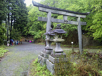  |
| Left: Stone Shrine Gate (Kakehashi), Right: Stone monument of Mizunomi-taijin-no-ato (a historical battle site) on Kirara-zaka Slope |
|
Go on the flat forestry road from Trail Board Number 66 to The Stone Shrine Gate at Trail Board Number 67. This place is called Kakehashi and is a light open space. From Trail Board Number 67, go down the left steep slope and cross Otowa-gawa River. Cross the river carefully especially when the water level is high. Cross two more small streams. The path merges with Kirara-zaka Slope at Trail Board Number 69. There is the Stone monument of Mizunomi-taijin-no-ato (a historical battle site). The path which comes up from Sekizan is the path for the Kaihogyo (a practice of walking around the mountain while paying visits to various sacred places.) It merges from north-west. Go up further, and you will get to the place where you can enjoy the splendid view to Ichijyoji area. |
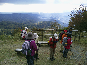 |
| The view from the south side of Hiei Station of Cable Car |
|
Around the place of Trail Board Number 71 the view is not good but is a good place for a rest in a grove of trees. At Trail Board Number 73-1, the path is divided into two, but both paths lead you to the cable station. If you take right path, turn left at Trail Board Number 73-3 among a reforested area and go to under the Radio Relay Station. You can enjoy a wonderful view of the city of Kyoto! The path which goes straight from Trail Board Number 73-3 is the path for the Kaihogyo. It is a shortcut to Hiei Garden Museum, Mt. Shimei-dake and the top of Mt. Daihiei (Great Mt. Hiei) through the Mt. Hiei Parking lot. If you take the left path from Trail Board Number 73-1 and go up alongside of the cable lines, you will get to the terminal of the cable car. The place around Trail Board Number 74 is the best for a rest and you can get a full view of the city of Kyoto. Note: there is no Eizan Cable Car operation during winter season, from December to March. 《Approximate time required》 Ginkaku-ji michi (No.51) (20min.← →20min.) Kitashirakawa Shibuse-cho (No.54) (15min.← →20min) Tree of Metasequoia (No.57-1) (20min.← →30min.) Mt. Uryu-yama (No.59-3) (10min.← →5min.) Fork point (No.60) (15min.← →20min.) Fork point to Ichijyoji forestry path (No.64) (45min.← →60min.) Stone Shrine Gate (No.67) (25min.← →25min.) Stone monument of Mizunomi-taijin-no-ato (No.69) (30min.← →50min.) Fork point ahead of Stone Monument of Chigusa Tadaaki (No.73) (10min.← →15min.) Hiei Station of Cable Car (No.74) Tree of Metasequoia (No.57-1) (20min.← →30min.) Fork point (No.60) When you take the course that goes through Mt. Uryu-yama: Ginkaku-ji michi (No.52-1) (3hours and 10min.← →4hours and 10min.) Hiei Station of Cable Car (No.74) |
| → Higashiyama Course (Trail Board Number from52-2 to 74) |
| → Eastern Kitayama Course (Trail Board Number 1 to 23 of Kitayama Course) |
| →High points |
| → Back to the Top of this Page |
| © Kyoto Trail Guide Association |